
Based on J. H. Parry, The Discovery of the Sea (University of California Press, 1981), and Peter Frankopan, The Silk Roads (Alfred A. Knopf, 2016)
There is a straight line from Marco Polo to Christopher Columbus, the eastward-looking Venetian to the westward-looking Genoese. — S. A. M. Adshead1
“All the seas of the world are one.”2 The four oceans — Atlantic, Pacific, Indian, and Arctic — are sections of a single body of water that covers more than two-thirds of the earth’s surface. Spilhaus’s projection of the globe onto a square vividly illustrates this fact.3

Sea routes connect every pair of coastal locations. These routes were almost entirely unknown in the middle of the fifteenth century. Their discovery was largely the result of voyages undertaken by European (predominantly Portuguese and Spanish) mariners. Their early goals were diverse and sometimes ill-defined, but towards the end of the fifteenth century, only a single goal remained: to reach “India,” the source of black pepper, nutmeg, and cloves.
The Silk Road
Alexander’s armies marched eastward, not westward, because that was where the world’s wealth and power lay. Roman armies marched in both directions, but the bulk of the wealth still lay in the east.
Rome’s transition into an empire had little to do with Europe…What propelled Rome into a new era was its reorientation towards the Eastern Mediterranean and beyond. Rome’s success and its glory stemmed from its seizure of Egypt in the first instance, and then from setting its anchor in the east — in Asia.4
Egypt produced huge grain harvests and had vast accumulated wealth, but for the Romans, it was also a gateway to Asia. The conquest of Egypt allowed Rome to tap into an active trade network, gaining access to goods from India, China, and the south seas. This network — the Silk Road — encompassed trade by land, through Central Asia, and trade by sea, through the Indian Ocean. By the end of the first century, Rome was an integral part of the network, importing tin, copper, lead, topaz, ivory, gems, spices, and of course, silk. Some of these items could only be found in Asia. China was the sole producer of silk. The Malabar coast was the only source of black pepper, and the Banda Islands were the only source of nutmeg and mace.

The Silk Road carried goods much farther than it carried people. Merchants transported goods to a distant market, then resold them to other merchants who did the same. The merchants took a little profit with each sale, and countries imposed transit taxes on the goods as they passed through. Trade was profitable. It was especially profitable for countries that could exercise exclusive control over routes, as the Kushan empire did,5 and as Egypt would do much later.
One consequence of this kind of trade was that people in the west and in the east knew very little of each other. Romans wore silks and spiced their food, but their knowledge of China and India consisted of little more than travellers’ tales. Trade continued in this way for a millennium. What finally allowed Europe to break out of its isolation was the Mongol conquest.
Genghis Khan led the Mongol tribes into China in 1211 and soon captured Beijing. He conquered Afghanistan and Persia in 1221. After his death in 1227, his sons and grandsons continued to build the Mongols’ domain.
The Mongols had two great strategic advantages. Their first advantage was their willingness to utterly destroy any place that resisted them. The assault on Nishapur is one example:
Every living being — from women, children and the elderly to livestock and domestic animals — was butchered as the order was given that not even dogs or cats should be left alive. All the corpses were piled up in a series of enormous pyramids as gruesome warnings of the consequences of standing up to the Mongols. It was enough to convince other towns to lay down arms and negotiate.6
The brutality of Nishapur was repeated over and over again. The conquest of China alone brought about the deaths of 35 million people, out of a population of about 115 million.7
The Mongols’ second advantage was that they were horsemen. They moved with such speed that they could “appear out of nowhere.” And once the fighting had started, a man on a horse was much more powerful than a man on foot. Each Mongol warrior had as many as twenty horses, so that he would always have a fresh remount. It is believed that the Mongols could “mobilize close to half of the horse population of the world, estimated at about 20 million at that time.”8
Horses need to be fed, though, and the Mongols’ need for grazing might have determined the limits of their empire. They withdrew from Europe, were pushed back from the shores of the Mediterranean Sea, and never ventured into southeast Asia. Nevertheless, late in the thirteenth century,
…the Mongol world had become so vast — stretching from the Pacific to the Black Sea, from the steppes into northern India to the Persian Gulf, that strains and cracks began to appear. The empire divided into four main branches, which became increasingly hostile to each other. The senior line was centred in China [ruling as the Yuan dynasty]; in Central Asia, it was the heir of Chaghatay [second son of Genghis]…who held sway. In the west, the Mongols who dominated the steppes of Russia and beyond into central Europe came to be known as the Golden Horde, while in Greater Iran the rulers were known as the Ilkhanids — a reference to the title of Il-Khan that marked them as subordinate to the main branch of the Mongol leadership.9
Despite their rivalries, the Mongols understood that they had a common interest in promoting trade. Two trade routes brought eastern goods into Europe. The land route passed through Mongol territory and terminated at the Black Sea, where both Venice and Genoa had established trading colonies. The sea route bypassed the Mongols: it carried goods across the Indian Ocean to Red Sea or Persian Gulf ports, and then overland to cities such as Alexandria and Damascus, where they were sold to Italian traders. The Mongols adopted policies that increased the attractiveness of the land route. These policies were so successful that “the Venetians did not send a single convoy to Egypt between 1323 and 1345.”10
One of the Mongols’ policies was to reduce the duties paid by merchants.11 Another was to make the land route safe for travellers.
“China is the safest country and best country for the traveller,” wrote the fourteenth-century explorer Ibn Battuta; this was a place where a reporting system that apparently accounted for each outsider on a daily basis meant that “a man travels for nine months alone with great wealth and has nothing to fear.” It was a view echoed by Pegolotti, who noted that the route from the Black Sea as far as China “is perfectly safe, whether by day or by night.”12
The journey from the Black Sea to China took between eight and eleven months. The safety of the route, coupled with the profits that could be made by eliminating middlemen, induced some Italian merchants to follow this route to its end. One of these merchants was Marco Polo, who travelled to China in 1271. He became one of Kublai Khan’s emissaries, an appointment that reflected the Mongols’ distrust of their Han Chinese subjects. Marco Polo spent the next two decades travelling in China and southeast Asia, returning to Italy in 1295. His account of his travels is the earliest European depiction of east Asia. It is wide-ranging and often perceptive, but sometimes devolves into the kind of fantastical tale told by other travellers of the time.
There was an island beyond China, according to Marco Polo, where the ruler’s palace had golden roofs and golden walls several inches thick. In India, the same author revealed, animal flesh was thrown into steep ravines that were filled with diamonds — but also infested with snakes — in order to attract eagles who would then fly down to retrieve the meat bringing the gems that were impressed into it up with them…Pepper, noted another traveller from this period, came from swamps filled with crocodiles that had to be frightened away by fire. In the accounts of contemporary travellers, the wealth of the east was legendary.13
Europe’s access to the land route lasted for perhaps half a century. Then the Black Plague spread through Eurasia, killing a large fraction of the population wherever it struck. Strangers were shunned as possible bearers of the disease, and trade along the overland route almost ceased.
Spices and silks could then be had only at the Mediterranean ports, primarily at Alexandria, and were purchased almost exclusively by Venetian merchants. Egypt’s sultan and the Venetian merchants recognized their monopoly power and pushed up their prices. Europeans were becoming wealthier, though, and were willing to pay high prices for luxury goods. The spice trade continued to grow.
Pepper, ginger, nutmeg and cloves were imported in increasing quantities, above all via Alexandria. On average, Venetian ships were bringing back over 400 tons of pepper per year from Egypt…By the late fifteenth century, nearly 5 million tons of spices were passing through Venice each year.14
Huge profits would be earned by anyone who could break the Venetian-Alexandrian stranglehold.
The Age of Sail
Francis Bacon declared, “Nature, to be commanded, must be obeyed.” It was a rule that the world’s sailors had long understood. The constraints within which they worked were vividly described by Arthur Quiller-Couch, writing just as steam was replacing sail.
A ship…is propelled by the wind. But the wind may be blowing from any quarter and at any angle to the ship’s course, and each of these directions has a name of its own. When…the ship has the wind right aft and is moving in exactly the same direction as the wind, she is “running.” When sailing as nearly in the teeth of the wind as she can possibly manage, she is said to be “close-hauled”…But no matter from what direction the wind be blowing, as long as it allows the ship to steer her course it is a “fair wind.” Anything beyond this is a “head wind,” and when the wind is coming steadily ahead the ship can only reach her destination by making a series of zig-zags or “tacks,” by each tack getting the wind sufficiently aslant to drive her forward. Suppose that a vessel at Dover wishes to get down Channel and that the wind is blowing…directly up the channel. It is clear that by attempting to sail straight down she will only be blown backwards. Her only course therefore is to slant across for the French coast, and then back from the French coast to the English, and so on until by means of these diagonals she finally clears the Channel. This making of tacks or boards is called “beating to windward,” and with anything like a strong head wind progress is, of course, very slow. Indeed, in that case, our captain would probably prefer to anchor in the Downs and wait until the wind shifted: and a century back, when steamships were not invented and everybody must depend on wind, it was no uncommon thing to see between four and five hundred sail of outward-bound ships anchored off Deal for weeks, waiting for an easterly breeze.15
In 1754, three centuries after the events described below, the novelist Henry Fielding sailed from England to Portugal. His ship needed “a month and a week” to clear the English channel.
Storm winds could be so strong that even an expertly handled ship would be driven downwind. This situation was survivable in the open sea, but it was potentially fatal if the ship was being driven towards land. In 1588 the Spanish Armada, harried by British warships and hampered by adverse winds, was forced to take the long way home: up the east coast of England and Scotland, and then down the west coast of Scotland and Ireland. Twenty-eight ships were lost on the southward journey, almost all of them driven onto the rocks of the Irish coast by strong west winds. About 5000 sailors and soldiers died.
A ship’s course was determined by the set of its sails — essentially, their angle relative to the ship’s hull — and not by its rudder. Neither the rudder nor the helmsman was strong enough to take a ship where the wind did not want it to go. On a beat the helmsman did no more than smooth out minor course deviations.
If a fifteenth-century ship were beating to windward, how close to the wind could it sail? Seamen of the time divided the circle into 32 points, and described a ship’s course by “points off the wind.” A ship could sail no less than six points off the wind: if it tried to sail more directly into the wind than that, the sails would not fill and the ship would lose its momentum. Points are separated by an arc of 11.25 degrees, so the smallest sustainable angle between the ship’s hull and the wind was 67.5 degrees. Basic trigonometry then shows that, at best, a ship beating to windward would move laterally 2.4 times as far as it moved forward.
There are two reasons why this calculation overstates a ship’s progress as it beats to windward. The first is “windage”: the wind striking the ship’s side pushes the ship slightly downwind. The second is the loss associated with switching from one leg of a zig-zag course to the next. This task can be accomplished in two ways, wearing and tacking.16 In wearing, the ship’s stern is turned into the wind. The sails are always filled — always powering the ship — but the ship is travelling downwind during the turn, giving up some its gains to windward. In tacking, the ship’s bow is turned into the wind. The ship’s sails are not filled, and generate no power, when the bow is pointed too directly into the wind, so the ship must begin the turn with enough momentum to carry it through the turn and onto its new heading. In the early fifteenth century, changing the set of the sails without losing momentum was so difficult that wearing was preferred to tacking. The sail plans used later in the fifteenth century facilitated tacking, and wearing became less common.

Ships
Before the last decade of the fifteenth century, voyages of exploration were almost always carried out in caravels. These ships were lateen-rigged during the first half of the century, after which square sails were added to the sail plan. The caravel was an agile ship, well-suited to coastal sailing, but also very able in open ocean. The surviving records suggest that caravels were seldom lost at sea. The caravel fell out of use only because it was too small to carry the provisions required for long voyages.
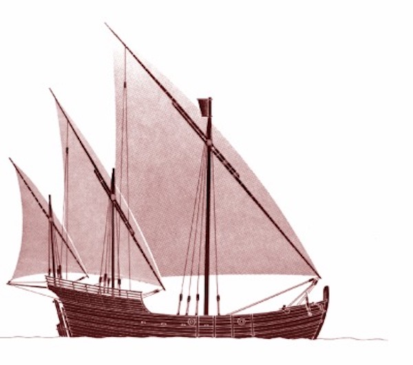
The image above is a reconstruction of a lateen-rigged caravel — no contemporary images have survived. Caravels were small ships, generally less than 60 feet (18 meters) in length. They required a crew of between 12 and 24 seamen. The crew had few amenities. The captain had a cabin built into the stern of the ship, but everyone else slept on the deck in fair weather, and on top of the cargo in the holds in foul weather. There was a sandbox on the deck in which a fire could be lit for simple cooking — but only in good weather. The food was “hard biscuit and beef or pork pickled in brine,” and perhaps salted fish in barrels. Water, too, was carried in barrels and was soon fouled by algae.
The ships of northern Europe were “clinker-built” — their hulls were formed of overlapping planks — from at least the time of the Viking longships. The caravels, though, followed the Mediterranean tradition. Their hulls were “carvel-built” — the planks met edge to edge. The planks in the earliest carvel-built hulls were joined at the edges, but joining had been abandoned by the fifteenth century. Instead, the hulls were waterproofed by hammering oakum (shredded hemp, usually from old rope) into the seams and coating it in tar. The deck was waterproofed in the same way.
A caravel probably drew less than six feet (two meters) of water, so it could pass through quite shallow areas. It had a straight keel, allowing it to easily settle on the bottom at low tide.
A sternpost and a stempost were joined to the keel, and both were almost vertical. The planking of the hull curved inward to meet both posts — the squared-off stern was a much later innovation. The rudder was attached to the sternpost.
The caravel had a full deck. The deck was built with a significant degree of “sheer,” meaning that it curved upwards at both the bow and the stern. A small ship in heavy waves pitches forward and back like a rocking horse. Sheer prevented the ship’s bow from digging into the waves and reduced the amount of water that came aboard in stormy weather.
Most caravels had two masts in the early part of the fifteenth century, with three masts becoming more common as the century progressed. The caravels initially used only lateen sails. The lateen sail was triangular, attached to a yard that sloped sharply downward.

The lateen-rigged caravel was highly maneuverable and performed well when beating to windward, but as the exploration of the oceans continued, these characteristics became less important. Ships began to make long voyages out of sight of land, sailing courses on which the wind blew from behind the ship or from its side. On these courses, square sails were more effective than lateen sails. Square sails were adopted gradually, but eventually the most common sail plan called for a three-masted ship with square sails on the first two masts and a lateen sail on the last. Each of the first two masts initially held only a single large square sail suspended from a very long yard. Soon, however, the square sail was split into two parts, with a smaller sail suspended above a larger sail — the first step towards the “tall ship.”
Navigation
Navigators made continuous records of the ship’s location so that they could report concrete information about routes and discoveries. Ideally, locations would be expressed in terms of longitude and latitude, concepts taken from Ptolemy’s Geography. Calculating longitude was a difficult problem that was not satisfactorily solved until after the major voyages of discovery had been completed. On the other hand, mariners could make rough estimates of latitude in the northern hemisphere even at the beginning of the fifteenth century, and new techniques were developed over the remainder of the century.
Longitude was inferred from “dead reckoning.” On each leg of the voyage, the navigator noted the course and duration of the leg. The course was determined with a magnetic compass, which had become a standard tool for mariners by the beginning of the fifteenth century. The duration of the leg was determined by a sand glass. The navigator, based solely on the “feel” of the ship, estimated the ship’s average speed over the leg.17 From time and speed, he calculated the distance travelled. He then consulted a set of traverse tables, which converted course and distance into changes in east-west and north-south position. These changes, coupled with the ship’s last estimated position, yielded a new estimate of the ship’s position. There was ample scope for error, and errors were cumulative.
The Pole Star was initially the key to determining latitude.
[The Pole Star] is aligned — not exactly, but near enough for the primitive navigator’s purpose — with the earth’s axis, so that its bearing, from any point where it can be seen, is due north or nearly so. It neither rises nor sets, but in clear weather is visible all night throughout the year.18
The Pole Star is visible only in the northern hemisphere. It is lower and lower in the sky as the observer approaches the equator, so its altitude — the angle between the star and the horizon — can be used to determine the observer’s latitude.
The methods used to determine the height of the Pole Star at the beginning of the fifteenth century were rough and ready — it was sometimes measured against an outstretched thumb. But the early navigators seldom needed to attach a numerical value to the Pole Star’s altitude, which they used primarily for “latitude sailing.” If they knew the altitude of the Pole Star at their destination, they would sail north or south until they achieved that altitude. They would then sail directly east or west (using a compass bearing) until they reached their destination.
The mariner’s quadrant, which was in use by 1460, allowed the Pole Star’s altitude to be accurately measured. It was
… a quarter of a circle with a scale from 0 degrees to 90 degrees marked on the curved edge, and with two pinhole sights along one of the straight edges. A plumb line hung from the apex. The sights were aligned on the star and the reading taken from where the plumb line cut the scale. Polar altitude in degrees gave the observer’s latitude — as every astronomer who had read his Ptolemy knew.19
The quadrant had a setting that allowed the observer to correct for the deviation of the Pole Star from the earth’s axis. Observational errors were caused mainly by the rocking of the ship, so sightings were taken on land whenever possible.
Finding latitude was more difficult once a ship had passed the equator, for there was no star like the Pole Star in the southern skies. Navigators learned to use the stars of the Southern Cross in its place. These stars move across the sky, so the time of observation was important. Navigators attempted to observe a star at its “meridian transit,” which corresponds to the moment at which its altitude is highest. They could not predict the moment of meridian transit because they did not have accurate clocks. They began to take sightings well before the meridian transit, and continued to take sightings until they were sure that the meridian transit had passed. The greatest altitude among their observations was taken to be the star’s altitude at the meridian transit.
Astronomers understood that, in principle, the sun’s altitude could be used to determine latitude. The relationship between the two was complex because the sun’s altitude systematically changes across the year. A convention of astronomers was needed to make sense of it.
John II of Portugal in 1484 convened a commission of mathematical experts to devise the best method of finding latitude by solar observation. Declination had long been studied by astronomers, and tables of declination existed in a variety of forms. Among the most accurate and detailed were those in the Almanach Perpetuum worked out for the years 1473-78 by the Jewish astronomer Abraham Zacuto of Salamanca. King John’s commission drew up a simplified version of Zacuto’s tables, brought them up to date, translated them from Hebrew into Latin, and devised a fixed procedure to enable an intelligent and literate seaman to use them.20
The “rule of the sun” required the sun to be observed at the meridian transit (local noon). As with the stars, the sun’s meridian transit could be determined only through repeated observations.
Other navigational rules soon followed. Navigation at sea became such a complex craft that schools of navigation were established in Lisbon and Seville in the early sixteenth century. It is sometimes claimed that “Henry the Navigator” established a school of navigation, or of seamanship, at Sagres in the early fifteenth century, but this claim has no factual basis.
Go to: The Discovery of the Sea II
- S. A. M. Adshead, Central Asia in World History (Palgrave, 1983). ↩
- Parry, The Discovery of the Sea, p. xi. ↩
- This version of the map was taken from ArcGIS StoryMaps. For clarity, the map shows two small areas twice: the Isthmus of Panama (far left and bottom) and the Bering Strait (top and far right). ↩
- Peter Frankopan, The Silk Roads, p. 15. ↩
- The Kushan empire formed in the first century and dissolved in the fourth. It included much of modern Uzbekistan, Afghanistan, Pakistan, and northern India, giving it control of the overland route. ↩
- Frankopan, The Silk Roads, p. 156. ↩
- Ronald Findlay and Kevin O’Rourke, Power and Plenty (Princeton, 2007), p. 103. ↩
- Findlay and O’Rourke, Power and Plenty, p. 103. ↩
- Frankopan, The Silk Roads, pp. 165-8. ↩
- Findlay and O’Rourke, Power and Plenty, p. 107. ↩
- The duties at the Black Sea terminus were 3-5 percent, while the duties in Alexandria were 10-30 percent. (Frankopan, The Silk Roads, pp. 172-3.) ↩
- Frankopan, The Silk Roads, pp. 178-80. Francesco Pegolotti was a Florentine merchant. ↩
- Frankopan, The Silk Roads, p. 177. ↩
- Frankopan, The Silk Roads, p. 189. ↩
- Arthur Thomas Quiller-Couch, The Story of the Sea (Cassell and Company, 1895), pp. 8-9. It should be noted that for sailors, an east wind and an easterly wind both blow from east to west. ↩
- If the ship is sailing six points off the wind, wearing turns the ship through an arc of 225 degrees, while tacking turns it through an arc of 135 degrees. ↩
- The “log and line” would become the standard method for measuring the speed of a sailing ship. The earliest written reference to this device dates to 1574, and it was not widely used for some time after that. ↩
- Parry, The Discovery of the Sea, p. 26. ↩
- Parry, The Discovery of the Sea, p. 146. ↩
- Parry, The Discovery of the Sea, pp. 148-9. ↩
