
Based on J. H. Parry, The Discovery of the Sea (University of California Press, 1981), and Alfred Crosby, Ecological Imperialism (Cambridge, 1986)
For such is the statute of the windes, which all Shipping in that Sea must obey: they must goe one way and returne another. — Samuel Purchas ( c. 1577 – 1626)
All of the world’s seas constitute a single body of water, so there is a sea route connecting each pair of coastal locations. These routes were mostly discovered by European mariners, with the Portuguese and the Spanish taking the lead. They were not searching for unknown lands, although they did find them. They were searching for new routes to known lands, especially to “India,” the source of black pepper, nutmeg, and cloves.
West Africa and the Islands
The Portuguese began to explore the coast of Africa in the 1420s. Their goals were primarily economic: they were looking for arable land, and they were looking for gold.
Portugal was a poor country. Most of its people were peasants, but there wasn’t much land that could be profitably worked.
More than half its area was stony, scrub-covered mountain, good only, at best, for rough pasture. Only the river valleys with their terraced vineyards, and the plains of the south with their cork and olive groves were really productive…Grain had to be imported in most years to supply the towns.1
Some islands off the coast of Africa were known to the Portuguese, and there had been transient sightings of others. Portugal could expand its agricultural base by colonizing some of these islands. Indeed, Castile had already colonized Lanzarote in the Canary Islands: the settlers fished, produced grain, and raised livestock.
Gold was used for coinage throughout Europe but was perpetually in short supply. Much of Europe’s “new” gold was acquired by trading in North African ports. The Europeans sold timber and shipbuilding materials to the North Africans, as well as cloth and glass beads for use in trans-Saharan trade, and copper for re-export to Sudan. They were paid in part with gold that North African merchants had brought across the Sahara.
In Gao, Timbuktu, and other cities on the middle bend of the Niger, Maghribi merchants were paid in gold, at extravagant prices, for the textiles, glass beads, copper, dried fruit and Indian Ocean cowries which their caravans brought in. The gold, they were given to understand, came from a region much farther south, vaguely known as Wangara. It was produced by primitive people whose chief need from the outside world was salt.2
The Portuguese hoped to cut out the North African middlemen by sailing down the coast of Africa until they found a source of gold.
These were the economic goals of the Portuguese — the idea of circumnavigating Africa to reach India came later. There were also non-economic goals, although they appear to have been less important. Many of Portugal’s early expeditions were commanded not by experienced sea captains, but by “knights, squires or gentlemen of the [royal] household” who embraced the crusader’s ethos.
A belligerent piety was traditional among them, a piety which sought expression not so much in converting an ignorant heathenry as in killing, humiliating or subduing the known enemies of Christ.3
For them, command was an opportunity to enhance their own reputation, or to serve an influential benefactor, or to share in a voyage’s profits. Their rapacity was partly responsible for the slow pace of early exploration. Why sail along a barren stretch of African coast when, farther to the north, there were Islamic merchant ships to be snapped up?
Another factor was widespread belief in an African kingdom ruled by a powerful Christian king, Prester John.
Wherever he was, if only he could be found and his help enlisted, the fortunes of war might be reversed, the infidel put down, and the unity of Christendom restored.4
Belief in Prester John persisted into the time of Vasco da Gama — but when da Gama had to choose between searching for the king and sailing onwards to India, he readily chose the latter.
The Portuguese began to colonize the Canaries, the Madeiras, and the more remote Azores around 1420. All three island groups had temperate or subtropical climates and were suitable for agriculture.
The islands’ heights are often craggy and rasp-edged, but there are broad areas of richly fertile volcanic soil. The all-enveloping ocean supplies most of that fertile soil with a plenitude of rain, although some of the less mountainous islands are parched, particularly the most easterly Canaries, which are too low to comb the moisture out of the trade winds.5
The most successful colony was Madeira. Alvise Cadamosto reported that when Europeans arrived, “There was not a foot of ground that was not entirely covered with great trees.” Timber became a valuable export crop, but in their haste to begin farming, the colonists set fire to large parts of the forest. The fire burned uncontrollably, at one point forcing settlers, “with all the men, women and children, to flee its fury and to take refuge in the sea, where they remained up to their necks in the water, and without food or drink for two days and two nights.”6 Even after the land had been cleared in this way, an enormous amount of work remained to be done.
Much of the land was too steep for normal practices of cultivation and had to be terraced. Most back-breaking of all the tasks, and the most dangerous, was the creation of a vast and complicated irrigation system to bring water from the windy and sodden uplands to the cultivated fields far below…[It was] a network of conduits and tunnels, some of mortar and some carved out of the living rock, that gird the mountains, collect the rainwater, and guide it along knife-edged ridges and yawning gorges down to the farms and gardens. Today its length is estimated at 700 kilometers, 700 kilometers on an island that is only 60 kilometers long.7
Slaves were brought in to perform the bulk of the manual labour. The majority of the slaves were Guanches, the people of the Canary Islands, who began to be taken as slaves even before the settlement of Madeira. The Guanches ferociously resisted domination, but eventually all of the Guanches were either enslaved or killed.8
The settlers initially produced grain, but switched to sugarcane, a much more valuable crop. Madeira was the world’s largest producer of sugar during the late fifteenth century, but then its output collapsed, in part because there was no longer enough accessible wood to fuel the refinery boilers. When Madeira switched to wine production, it had to import the wood needed to make the barrels.
Exploration along the African coast occurred slowly and fitfully. Voyages were expected to be profitable, but sailing on the African coast was often difficult and the opportunities for trade were limited. There were no significant profits until the Portuguese began to enslave Africans in the 1440s. The Portuguese first acquired slaves by sending raiding parties ashore, but when they began to encounter determined resistance, they switched to trade. Wheat, salt, cloth, and horses were exchanged for captives. As the chronicler Zurara disdainfully explained, “The affairs of these parts were henceforth treated more by trafficking of merchants than by bravery and toil in arms.”9
The slave trade “depended on establishing good relations with the African rulers and there was no question of forts, slave raids or conquests.”10 An exception to this rule was the fortified trading post built at Elmina (“the mine”) on the Gulf of Guinea. The coastal people had been mining gold there for decades. They had been selling their gold to the trans-Saharan merchants, but readily sold to the Portuguese in their place. Inland peoples, notably the Ashanti, also began to sell their gold at Elimina. The trading post also served as a transshipment point for slaves, but slaves were not bought locally, for fear of upsetting the gold trade.
From the Gulf of Guinea to India
For the Portuguese, reaching the Canary Islands was simple but getting home again was problematic.
The course from Iberia to the Canaries is often about as straight as a sailor can sail, because usually both current and wind carry him to his destination,…but to return by anything approximating the same route he must tack to and fro, to and fro, for many days, sliding backward every time the vessel comes about, and gaining little on the best reach, because the current is relentlessly contrary. If he sails conservatively, his only hope is to shave the coastline, taking full advantage of the shore winds that blow from the south and southwest during the hours immediately before and after dawn…Much of the real hope of northing lies in the strength in the backs of his oarsmen, but where on that inhospitable coast is there food and water to keep them going?11
The Portuguese, unwilling to fight both wind and current, chose to sail northwest into the open ocean. They sailed “close-hauled” — as close to the wind as they could — but their course nevertheless carried them farther away from home. When they had sailed far enough north to reach the westerly winds that blew onto Portugal, they turned east and sailed for home with the wind behind them. The Portuguese called this strategy the volta do mar.
Explorers had no understanding of the wind systems through which they sailed, but the volta do mar taught them that the winds could be used strategically. This knowledge proved to be invaluable when, during the reign of John II (1481-1495), the Portuguese began a deliberate search for a sea passage to India.
Explorers continued to push south along the African coast. In 1487 an expedition led by Bartolomeu Dias was able to reach the Orange River12 despite opposing winds and currents, but then encountered fierce storms. Dias, fearful of being driven onto the land, set out to sea. He sailed close-hauled to the southwest until he encountered westerly winds, then turned east to run with the wind behind him. Dias eventually made landfall at Mossel Bay — he had rounded the tip of Africa by executing an upside-down volta do mar. He went no farther, turning back to quell a mutiny among his men.
The Portuguese, distracted by their fractious dealings with Castile and their military adventures in Morocco, did not make use of Dias’s discovery until a decade later. Vasco da Gama, commanding a fleet consisting of three medium-sized ships and one caravel, sailed from Portugal in 1497. He followed the African coast until he reached the Cape Verde Islands, then turned his ships into the open ocean. Sailing southwest and then south, as the prevailing winds allowed, he eventually reached a zone of favourable winds that allowed him to sail due east. He made landfall at St. Helena Bay. From the Cape Verde Islands to St. Helena Bay, da Gama had sailed out of sight of land for eighty-four days. “In distance and duration,” this passage “dwarfed Columbus’s longest voyage.”13
Da Gama rounded the tip of Africa and made his way up the eastern coast, eventually connecting with Asia’s massive trading network.
Across the seas and oceans of this immense world there flowed a multiplicity of trades, both local and long-distance. In the ports of western India, some in touch with East Africa, the Red Sea, the Persian Gulf and Malaya, merchants from the Middle East exchanged European metals and bullion for Indian and imported spices. North African Moors traded to Malaya. Indian textiles were sold for gold and ivory in East Africa. With distances so vast — from western India to East Africa is over 4000km, and from southern Malaya to western India about the sane — commercial currents so many and varied, and the peoples and natural conditions encountered so diverse, the major trades had over the centuries come to be handled through a number of entrepôts. These were cosmopolitan ports of transhipment at which, usually for geographical or climatic reasons, vessels were obliged to stop. Nowhere was this clearer than in the Indian Ocean itself, where the monsoons blowing from the north-east (November-April) and the south-west (May-October) rigorously determined the movement of shipping. Hence in southern Malaya, where the wind system of the Indian Ocean met that of the China seas, Malacca had by 1500 emerged to eclipse all predecessors. The wealth of this “richest place in all the world” was to strain Portuguese resources in metaphor and simile. It was “the mine of spices” to which all Asia was drawn as surely “as rivers flow to the sea.” Here were to be found alike merchants from Tunis and China; ships from India; junks from Okinawa. It gathered in Chinese silks, Indian textiles, East Indian spices, Sumatran gold, and European goods that had travelled the long route from Cairo and Aden…Far less inviting, but equally important, was Aden, strategically sited — on bare rock and in stifling heat — at the juncture of the Red and Arabian seas. It controlled, the Portuguese later reported, “an unbelievable commerce,” re-shipping spices to Cairo and Damascus, exporting African gold, choice opium, Arabian horses, Yemeni dyes and European cloths to the east. Handling a very similar trade, and enduring a very similar, if not worse, climate was Hormuz, at the mouth of the Persian Gulf. It stood on a barren island producing only salt and sulphur, and to which even water had to be fetched. Yet here again the Portuguese were to find a stylish city, rich on what was channelled through it. It more or less monopolized the commerce between India and Persia…and its coins of gold and silver circulated widely in Asia.14
Da Gama’s mission required him to engage with Asians who were wealthy, sophisticated, and worldly. It was a task for which he was spectacularly ill-suited and ill-prepared.
Scufflings in Mozambique led to his bombardment of the city; at Mombasa gracious gifts were repaid with cheap beads. Only in Malindi, whose ruler had hopes of assistance against neighbouring Kilwa, could a pilot be found…Under his guidance the Portuguese made a fast passage to western India, eventually reaching Calicut…Here da Gama’s proceedings produced much the same results as in East Africa. Attempts to enter the spice trade were impeded by a lack of suitable goods to trade, and the initial goodwill of the Hindu raja was quickly dissipated by arrogant Portuguese disregard for the elaborate formalities of oriental custom. More fundamentally still, the dominant Moslem merchants, informed of Portuguese behaviour in Africa, had no desire to see their commerce destroyed, nor was the raja prepared to forfeit their goodwill and the revenues their presence ensured by favouring piratical strangers.15
Da Gama eventually acquired a cargo of pepper and sailed for Portugal, where his accomplishments were lavishly celebrated. But the future would not unfold as the Portuguese had imagined. They had hoped to be traders; they became pirates and extortionists. They grew wealthy all the same.
The Americas
Well-educated Europeans of the fifteenth century were familiar with Greek philosophy. They had learned from Aristotle that the sublunar world consisted of nested spheres of earth, water, air, and fire. Dry land existed only because the spheres of earth and water did not have a common center, allowing the sphere of earth to partially emerge from the sphere of water.16 The resulting landmass was rugged at its edges, and islands were scattered along its coasts, but it was essentially circular. Europeans had learned from Ptolemy that on this earth-and-water globe, the landmass stretches out over 180° of longitude. In principle, one could travel from Spain to China by going eastward over land or westward over water. Seneca thought that the latter route would be the easier one: “A ship may sail in a few days with a fair wind from the coast of Spain to that of India.”17

Columbus and his contemporaries knew that Seneca’s assessment was wildly optimistic. Paolo dal Pozzo Toscanelli (1397 – 1482), a mathematician and cartographer, after carefully studying Marco Polo’s Travels, estimated the distance between the Portuguese and Chinese coasts to be about 9000 kilometers. Columbus was aware of this estimate and knew that it was too great a distance for the ships of his time. He made his own calculations.
According to Ptolemy the land area of the world covered 180 degrees of longitude…For Columbus, the remaining 180 degrees of water were too much. He found a more acceptable figure in the Cosmographiae Tractatus of Pierre d’Ailly…[who], following Marinus of Tyre in preference to Ptolemy, allotted 225 degrees of longitude to the land and only 135 degrees to the water. Cardinal d’Ailly, however, had known nothing of Marco Polo, who had revealed to Europeans the enormous east-west length of Asia. Columbus therefore added 28 degrees of land for Marco Polo’s discoveries, and a further 30 degrees to allow for the reported distance from the Cathay coast to the island of Cipangu [Japan]. This left only 77 degrees of longitude between western Europe and Cipangu, from which a further 9 degrees could be subtracted, since Columbus proposed to embark on his ocean passage from the western Canary Islands, leaving 68 degrees. By a final arbitrary correction, almost breathtaking in its illogic, on the assumption that Marinus had overestimated the length of a degree, Columbus succeeded, to his own satisfaction, in reducing this 68 degrees to 60 degrees.18
Columbus needed an estimate of the width of a degree of longitude at the equator in order to convert degrees of longitude into distances. His estimate was three-quarters of the true value. He concluded that the distance between Japan and the Canary Islands was 4400 kilometers — a long but manageable distance. The true distance is almost 20,000 kilometers.
Columbus’s proposal to reach China by sailing westward was presented to Portugal’s king but rejected. Perhaps the king’s experts understood that Columbus had skewed the numbers. Almost certainly they recognized that China was a long way from India. It was India’s spices that the Portuguese wanted, and a passage around Africa was the more sensible route. Columbus then appealed to Isabella I, the queen of Castile. She supported the proposal, possibly to avoid being shut out of the east by the Portuguese.
Sailing from the Canary Islands allowed Columbus to exploit the fair winds of the first leg of the volta do mar. He reached land after thirty-three days at sea, making his landfall in the Bahama chain. He imagined himself to be off the coast of Cipangu, and planned to find Cipangu before sailing onwards to China. He instead found Cuba and Hispaniola. After losing Santa Maria on a reef, he sailed for home. His voyage lasted a total of thirty-two weeks.
The reactions to Columbus’s discoveries were varied. The Spanish were delighted, the Portuguese unperturbed, the Germans indifferent. Columbus’s voyage was widely discussed in Italy, where the centrality of trade inspired an interest in geographical matters.
The news traveled rapidly, not only through printings of Columbus’s Letter but also through private letters written by Italian diplomats and businessmen in Spain to correspondents at home…Phrases such as “islands in the Indian Ocean,” “islands of India,” “islands towards the Orient” occur in most of the surviving letters; but Asia as everyone who had read Marco Polo knew, covered an immense area and its peoples were extremely diverse. This knowledge, perhaps, explains the initial Italian indifference to the commercial implications of Columbus’s voyage. Even in Venetian comment there was no hint of alarm, no indication of fear that the westward passage to the Indies might undercut and damage the oriental trade which brought such profits to Venice. Informed Italian opinion seems to have accepted, at first, that Columbus’s islands lay in, or near, some region of Asia, but a remote and primitive region, far from any of the places in which Europeans were commercially interested.19
The term “New World” was introduced to describe these “remote and primitive” islands — only later would it be associated with new continents. The realization that there were new continents came slowly. For Columbus, it came in 1498 when he reached the mouth of the Orinoco River. More evidence of a continental landmass was produced by a generation of explorers — Cabral, Cabot, Ojeda, Vespucci — who traced out sections of an unbroken coastline.

The first formal recognition of a new continent was Waldseemuller’s world map of 1507. He showed the New World as a continent, which he named America after Amerigo Vespucci. Waldseemuller’s map
… was an inspired guess…but it was not immediately or universally accepted. It contradicted a great body of accepted theory, and was inadequately supported by eyewitness knowledge. No European explorer had actually seen the west coast of continental America. No one could be sure whether or not America was separated from Asia; whether or not another ocean lay to the west.20
This doubt was removed in 1513, when Vasco Nunez de Balboa crossed the Isthmus of Panama to find a great ocean spread out before him.
The Pacific Ocean
Ferdinand Magellan would soon discover the true size of this ocean. The Spanish, fearful of being boxed out of the spice trade by the Portuguese, had commissioned him to find a westward route to India and the spice islands. This route would cross the Atlantic Ocean, round the southern tip of the New World, and then cross the Pacific Ocean.
Having crossed the Atlantic Ocean and spent the winter anchored safely on the Patagonian coast, Magellan searched for a way to get around the mainland, eventually finding the narrow, twisted and stormy strait that now bears his name. Magellan made his way through to the Pacific Ocean in 38 days, and according to the information available to him, a few weeks of sailing would take him to the spice islands. His information was wrong: it placed the spice islands much farther to the east than they actually were.
Magellan did not know the wind systems of this ocean but, by chance or intuition, chose a nearly ideal route. Even with day after day of favourable winds, Magellan and his men were worn down by the desperate privations of deep-water sailing.
They were at sea for nearly four months, reduced to scraping the barrels for powdered wormy biscuit, eating rats, chewing sawdust, gnawing leather, suffering all the torments of hunger, thirst and scurvy.21
Twenty people were dead of scurvy, and many more afflicted, before the expedition reached Guam in the Marianas, where they were able to reprovision the ships. They then sailed on to the Philippines. Magellan was killed there after involving himself in a local dispute. The expedition’s surviving members obtained a local pilot who guided them to the Moluccas, where they were once again in familiar waters. One of the expedition’s ships, Victoria, would go on to complete the circumnavigation of the world, but from a geographical perspective, the expedition was already a success. A major gap in Europe’s knowledge of the seas had been filled in.
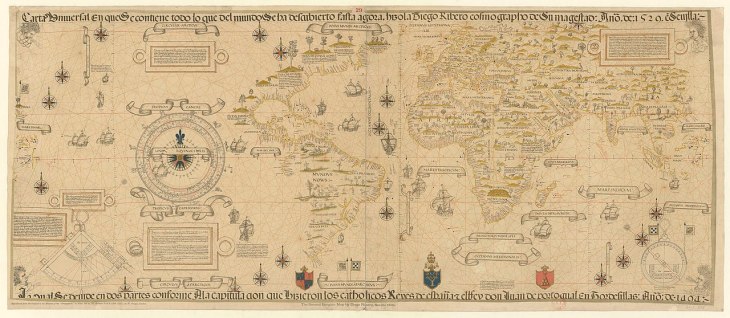
Victoria returned to Seville in 1522. A few years later, in 1529, Diogo Ribeiro produced a map of the world that incorporated the hard-won knowledge of Magellan and his predecessors. The difference between this map and Fra Mauro’s map of 1459 is striking. Mauro’s map combined observation, travellers’ tales, and pure fantasy. The whole map was bent into a shape consistent with Aristotelian orthodoxy. Ribeiro’s map, by contrast, makes no concessions to the nested spheres hypothesis. This hypothesis could not be reconciled with the existence of the South American continent — a landmass antipodal to Eurasia — and scholars had abandoned it in the early sixteenth century. The world was now imagined to be a single earthen sphere with water lying in depressions on its surface.22 As well, everything in Ribeiro’s map is factual.
It includes no information which had not been confirmed by actual exploration. It cites its sources. It owes nothing to hearsay or traditional authority. Areas where the facts were unknown — the north Pacific, much of the west coast of America, the Arctic, and the great circuit of the southern ocean — are left blank.23
The two maps reveal a dramatic change in the perception of the physical world, the product of only seventy years of ocean exploration.
- Parry, The Discovery of the Sea, p. 81. ↩
- Parry, The Discovery of the Sea, p. 77. Wangara’s location was never found, not by North African merchants and not by European coastal explorers. ↩
- Parry, The Discovery of the Sea, p. 89. ↩
- Parry, The Discovery of the Sea, p. 48. ↩
- Crosby, Ecological Imperialism, p. 72. ↩
- Both quotes from Cadamosto, The Voyages of Cadamosto. ↩
- Crosby, Ecological Imperialism, p. 78. ↩
- The elimination of the Guanches was largely the result of Spain’s decision to take complete and absolute control of the Canary Islands. ↩
- Quoted by Malyn Newitt, A History of Portuguese Overseas Expansion (Routledge, 2005), p. 24. ↩
- Newitt, A History of Portuguese Overseas Expansion, p. 25. ↩
- Crosby, Ecological Imperialism, p. 112. ↩
- The Orange River forms part of the border between Namibia and South Africa. ↩
- Crosby, Ecological Imperialism, p. 118. ↩
- Geoffrey Scammell, The World Encompassed (Methuen, 1981), p. 234. ↩
- Scammell, The World Encompassed, p. 234. ↩
- Reconciling the existence of dry land with the nested spheres hypothesis was a significant issue for medieval scholars — see David Wootton, The Invention of Science: A New History of the Scientific Revolution (Harper, 2015), pp. 112-16. ↩
- Seneca, quoted by Parry, The Discovery of the Sea, p. 187. Here, “India” should be understood to mean the coast of China. ↩
- Parry, The Discovery of the Sea, pp. 188-9. ↩
- Parry, The Discovery of the Sea, p. 210. ↩
- Parry, The Discovery of the Sea, p. 227. ↩
- Parry, The Discovery of the Sea, p. 249. ↩
- Wootton, The Invention of Science, p. 136. ↩
- Parry, The Discovery of the Sea, pp. 259-60. ↩
